Love the idea of idling from your backyard into Boca Ciega Bay in minutes? In Tierra Verde, that dream is real, but the details matter. Channel depths, marina access, and flood rules can shape your boating routine and your budget. This guide gives you clear, practical steps to match your boat and lifestyle to the right home, with the key checks to make before you buy. Let’s dive in.
Why Tierra Verde draws boaters
Tierra Verde sits at the southern tip of Pinellas County with quick access to Boca Ciega Bay and short runs to Gulf passes. You can reach popular islands and fishing grounds with ease when conditions cooperate. Marinas at the north end of the island place you close to marked channels and services. The location is ideal for day boating, nearshore fishing, and island hopping.
Depths, channels, and your draft
Not every canal or channel on the island supports large boats. The North Channel had a reported controlling depth of 3 feet in 2022, and area passages are prone to shoaling, according to the Coast Pilot. Tidal currents in Pass‑a‑Grille Channel average about 1.2 knots on flood and 1.4 knots on ebb, which can matter for narrow, marked routes. Use up‑to‑date charts, and verify recent soundings with local marinas or a marine surveyor before your first transits. You can review baseline guidance in the NOAA Coast Pilot for this area.
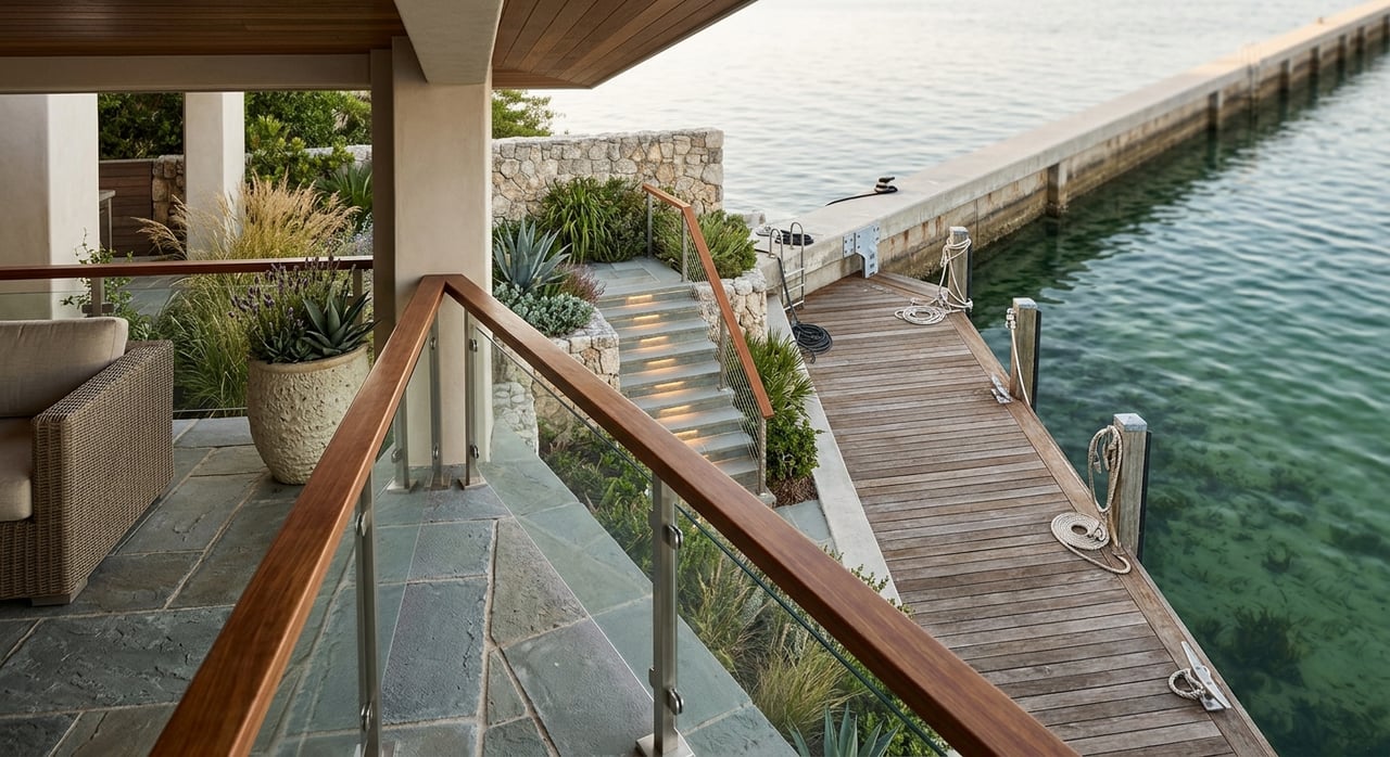
Marinas and storage options
Tierra Verde offers wet slips, high‑and‑dry storage, fuel, pump‑out, and repair services across its marina businesses. County planning lists two principal facilities by address: Tierra Verde Marina at 100 Pinellas Bayway S and the resort‑style facility at 200 Madonna Blvd. This inventory is helpful for slip counts and on‑site amenities.
- See the county marina inventory for addresses and amenities: Pinellas County planning marina list
For larger vessels, approach depth is critical. Port 32 at 200 Madonna Blvd advertises full‑service amenities, valet‑style storage, and options that can suit bigger boats. Always confirm the reported minimum channel depth to the facility and mean‑low‑water depths at the slip directly with marina staff before assuming Gulf access.
- Explore services and contact details: Port 32 Tierra Verde
Public ramps and trailer life
If your home will not have a dock, the Fort De Soto Park public ramp is a major convenience nearby. Pinellas County notes that boat‑ramp amenities, including floating docks, may be limited while repairs are underway. Before you plan a busy‑weekend launch, check the current ramp status and parking details.
- Current status and park details: Fort De Soto Park boat ramp
Property types and boating fit
Different property types serve boaters in different ways. Here is what to expect:
- Waterfront single‑family homes. Many canal homes include docks, lifts, and seawalls. Your usable capacity depends on canal depth and width, dock construction, lift rating, and any HOA or permit limits. Never assume a pictured dock equals deep‑water access.
- Deep‑water lots or protected basins. These are rare and valuable. If a listing mentions large‑yacht docking, verify mean‑low‑water depth, approach channel depth, and any bridge clearances with charts and local knowledge.
- Condos or townhomes. Slips may be owned by the association or assigned with rules on size, transfer, waitlists, and separate fees. Review the condo declaration and slip‑use agreements. Florida law outlines key disclosure and governance for HOAs and condos.
- HOA statute: Florida Chapter 720
- Homes without docks. Many owners rely on nearby public ramps and transient marina slips. Consider where you will store the trailer, how you will handle peak‑season ramp lines, and what your backup plan is during maintenance closures.
Permits, flood risk, and insurance
Waterfront improvements require planning. New docks, seawalls, or shoreline work often need state and county approvals. Florida’s water resources statute is a primary authority, and permits can be complex if work occurs near sensitive areas or seaward of certain lines. If the property sits in an HOA, architectural approvals may also apply.
- Regulatory reference: Florida Statutes Chapter 373
Flood and insurance can shift your total cost of ownership. Use the Pinellas County Flood Map Service and the FEMA Map Service Center to check whether the property is in a Special Flood Hazard Area. Ask for any Elevation Certificate, past flood claim history, and current flood policy information. Get quotes from both NFIP and private carriers early to understand premiums at the exact address and elevation.
- Address‑level maps: Pinellas County Flood Map Service Center
- Official FEMA mapping: FEMA Map Service Center
Environmental and on‑water rules
Tierra Verde sits within the Boca Ciega Bay Aquatic Preserve, which protects seagrass and marine habitat. Expect manatee zones and seagrass protection rules that limit speed or restrict shallow‑water operation. Operate carefully in sensitive areas to avoid prop scarring and to follow posted signage.
- Learn about habitat protections: Boca Ciega Bay Aquatic Preserve
Your due‑diligence checklist
Use this buyer checklist before you write an offer or during inspection:
- Dock and seawall records. Request as‑built drawings, permits, recent inspections or repairs, lift capacity, and proof of ownership or authorization for any submerged‑lands use.
- Depth verification. Get a recent depth profile at mean low water for the approach and the dock. Confirm bridge clearances on your planned routes.
- Elevation and flood data. Ask for the Elevation Certificate, confirm FEMA and Pinellas flood maps, and obtain current NFIP and private flood quotes.
- HOA or condo rules. Review dock and boat size limits, slip transfer rules, maintenance responsibilities, and any current or pending special assessments.
- Marina and storage plans. Confirm wet‑slip availability, transient policies, fuel and pump‑out hours, repair options, dry‑stack waitlists, and hurricane storage procedures.
- Local planning activity. Review public notices for any marina redevelopment or dredging projects that could affect services, traffic, or access.
- Environmental zones. Confirm speed zones, manatee areas, and seagrass protections for your nearby waterways.
Match home location to your boating style
Deep‑draft or larger yacht
Focus on homes with documented deep‑water approaches or plan to base the boat at a deep‑water marina. Verify mean‑low‑water depths and channel approach data with the marina and up‑to‑date charts.
Trailer and launch boater
Prioritize proximity to reliable public ramps and places to store a trailer. Check the Fort De Soto ramp status and consider peak‑season parking and launch times in your weekly routine.
Weekend fisher and day‑boater
Smaller center consoles and bay boats can work well with many Tierra Verde docks and marinas. You will enjoy quick access to nearshore grounds and local islands when depths and tides align.
Kayak and paddleboard
Calm bay channels and access to conservation areas offer scenic paddling. Learn local seagrass rules and avoid running motors in shallow grass flats.
Ready to tour with a plan?
If Tierra Verde is on your shortlist, a little homework will go a long way. I help you weigh draft, channel access, storage options, and flood considerations so your home and boat work together from day one. For a tailored shortlist and a step‑by‑step plan, schedule a free consultation with Rosalinda Patino.
FAQs
Can I keep a 40‑plus‑foot yacht at a private dock in Tierra Verde?
- Possibly. It depends on approach‑channel depth, mean‑low‑water depth at the dock, dock structure and lift capacity, and permits. Many larger boats choose deeper private marinas instead.
How do I confirm reliable Gulf access for a larger boat?
- Verify the minimum approach depths to your dock or marina at mean low water, review current charts, and speak with marina staff or a local marine surveyor about recent shoaling.
What permits do I need to build or repair a dock?
- Expect to work with state and county permitting, and HOA approvals if applicable. Florida’s water resources laws regulate many waterfront improvements.
How do I check flood risk and insurance for a specific home?
- Use the Pinellas County Flood Map Service and FEMA Map Service Center, request the Elevation Certificate, and get both NFIP and private flood quotes before you commit.
Where can I launch if my home does not have a dock?
- The Fort De Soto Park public boat ramp is nearby. Check the county’s page for current ramp status and any temporary limitations before you go.
